HDRFS researchers delve into the science of smoke plumes
By creating three-dimensional reconstructions of smoke plumes, scientists can better forecast air quality and predict the likelihood of spot fires.
By Amanda Heidt
March 2025
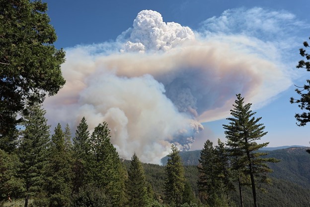
HDRFS researchers are leveraging new technology to study the formation and evolution of smoke plumes, such as this one, from the Mosquito Fire in 2022.
Credit: Cal Fire
Late in 2022, a wall of smoke from the nearby Mosquito Fire swept into Reno, Nevada, like a wave, turning the town into what Joseph Marino, a graduate student at the University of Nevada, Reno (UNR), remembers as a “biblical scene” of darkened skies, a blood-red sun, and air that was painful to breathe. It was the worst smoke inundation in Reno in recorded history, prompting widespread closures and landing the town on the American Lung Association’s “most polluted cities” list.
“It was definitely not a fun time,” Marino says, adding that when he first looked at his weather app, he assumed the air quality index ratings—which exceeded 900, when anything over 100 is generally considered unhealthy—were mistakes. “I’ve still never seen anything so high, but my worry is that events like this will become more common.”
The smoke front from the Mosquito Fire in 2022 prompted the worst smoke inundation in Reno in recorded history, darkening the skies for weeks. Credit: National Weather Service Reno
Based on that experience, Marino, currently a master’s student in the lab of UNR atmospheric physicist Neil Lareau, is now interested in how data can be harnessed to better track smoke fronts and inform forecasters about potential air quality disruptions. Indeed, Lareau and his research group, which falls under the fire emissions and their atmospheric aging (FEAA) component of the Harnessing the Data Revolution for Fire Science (HDRFS) project, are currently pursuing several projects aimed at gleaning valuable information from smoke plumes.
Keen to learn from the Mosquito Fire, Marino tapped into a community science initiative called Purple Air that offers affordable air sensors to the public, who then feed their data into a crowdsourced network. He used information from roughly 300 sensors to create a model of the Mosquito Fire’s plume, revealing that it behaved similarly to a cold front, in which a mass of cold air is pushed forward to replace warmer air. It’s hard to reconcile the idea of smoke and cold temperatures, Marino admits, but a phenomenon called smoke shading means that smoke can sometimes absorb or reflect incoming solar radiation before it reaches the ground, thus cooling the land beneath and driving the smoke on towards warmer areas (in this case the city of Reno).
“This certainly isn’t a new phenomenon, but many of the papers on smoke shading are from the 1980s,” Marino says, noting how far the technology has come since then. “With this Purple Air data, we can now track these ‘cold-smoke’ fronts in real time—which is especially important in remote, mountainous areas—and hopefully give forecasters and communities some advance warning.”
Lareau, meanwhile, is interested in the particles contained within the smoke, particularly the larger ones that may cause spot fires to flare many miles away from an active burn. Currently, he says, there are a lot of unknowns about how fires ignite, how different materials burn, and where the ash is likely to land and risk starting a new fire. Because fires can create their own weather patterns, it’s not always as simple as following the prevailing winds.
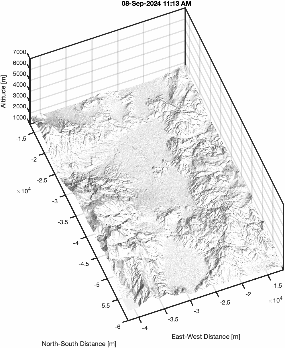
Click GIF to see animation. University of Nevada, Reno, atmospheric physicist Neil Lareau used LiDAR to create this three-dimensional model of the 2024 Davis Fire, which caused air quality in Reno to plummet. Credit: Neil Lareau
His team recently used weather radars and LiDAR to create a three-dimensional model of the smoke plume from the Davis Fire, which burned roughly 6,000 acres just south of Reno in September and also caused air quality in the area to plummet. Unlike the Mosquito Fire, the Davis Fire created a “hot smoke” plume—one that is propelled upwards into the atmosphere by the fire’s heat—and the team’s model helped track the development, progression, and dilution of the plume, “all of which can in turn say something about how fires evolve,” Lareau says.
But while these tools tell scientists something about the amount of particulates in the plume and give a general estimate of their size, they can’t reveal much about the specifics, such as what the particles are made of or how long they can smolder as they’re carried along. To get at this information, Lareau is partnering with colleagues at the nearby Desert Research Institute (DRI) on a citizen science initiative called Project Ashfall that encourages residents to send in pictures of ash particles near them. To date, many hundreds of people have contributed to the database.
“We’re learning a lot by combining these two streams of information, the plume dynamics and the nature of the particles,” Lareau says. “If I know the size and shape of these ash particles, I can model the aerodynamic trajectory that they take, and soon we’ll start investigating which kinds of particles are most likely to start a spot fire.”
One day, Laraeu says, he’d like to see the predictive capabilities for wildfires match that of today’s weather warning systems, which can provide advanced notice of storms several days ahead of time. “There’s a pressing societal need to understand where fire is going to be in the next hour,” he says. “If we’re going to be proactive, and not reactive, when it comes to things like evacuation warnings, we need to move to a space where our modeling allows us to do the same thing for wildfires.”