Q&A: Artificial intelligence comes to wildfire prediction
Mojtaba Sadegh leverages AI to create powerful models that bridge wildfire science and big data.
By Amanda Heidt
May 2025
It seems there’s no aspect of modern science that artificial intelligence (AI) hasn’t touched. From experimental design to the way we analyze and communicate our findings, AI-powered tools are now allowing researchers to pull together disparate data streams and tease out otherwise hidden connections.

Mojtaba Sadegh, Boise State University
These resources have the potential to bring powerful new insights to the study of big data and wildfire science, particularly as the direct human exposure to wildfires across the United States has more than doubled over the last two decades, says Mojtaba Sadegh, a civil engineer at Boise State University in Idaho. The keynote speaker at this year’s annual Harnessing the Data Revolution for Fire Science (HDRFS) meeting, Sadegh presented his group’s work at the nexus of wildfires, climate, and human impact, including projects harnessing AI to create predictive tools for wildfire risks. Among his recent publications are models assessing wildfire ignition probability across the American West alongside those for gauging vegetation and soil burn severity following the 2021 Dixie Fire in California.
Below, Sadegh shares more about his research, the promises and pitfalls of working with AI, and the potential for collaborations with the HDRFS team.

Mojtaba Sadegh during his keynote presentation at the 2025 HDRFS Annual Meeting. (Credit: Mayara Cueto-Diaz)
How did you come to be the keynote speaker at this year’s meeting?
It’s true that I’m not officially involved in the HDRFS project, but I met [Cyberinfrastructure Innovations (CII) component lead] Scotty Strachan at the Mountain Climate Conference last year, and we immediately started discussing how I could get more involved.
The work is complementary to mine, and it was a great opportunity to come and present, but also to learn about the systems in Nevada specifically. Because of the meeting, I’m now in discussion with three separate groups from HDRFS on how we can work together.
How would you describe the landscape of wildfires in the Western United States, and what can we say about the threats that fires are or are not posing to people?
Most wildfires across the eleven Western states are human-started. And although human-started fires tend to be smaller than naturally-occurring ones – because they usually occur closer to roads and infrastructure where they can more readily be suppressed – they often pose a greater risk to humans. So even though human-started fires account for about 40% of the total burned area in the Western U.S., they claim an absolute majority of the adverse human impacts.
What’s keeping my mind busy are these fires that burn along and into the wildland-urban interface (WUI), in places that are threatening human assets. In a recent study of ours, we found that the majority of the most dangerous and disastrous fires in California occurred within one mile of the WUI. And so what happens is that these fires start in the wilderness and encroach on an urban area so quickly that fire suppression resources will have to either focus on evacuating people or suppressing the fire early on. And so we start to have to confront really difficult decisions.
You also talked in your presentation about the primary and secondary risks that fires pose to communities. Can you walk me through that?
The statistic I often share from our work is that about 600,000 people in the continental United States have experienced primary exposure to wildfires between 2000 and 2019, and that about 21 million people have experienced secondary exposure in that same timeframe.
What we mean is that fires have a variety of different impacts that are both immediate and secondary. All of the people that fall within the burn area are of course hugely impacted, and they’re experiencing primary risk. But there are also secondary impacts, and here we mean things like evacuation orders and smoke. Smoke impacts a much wider area over a longer timeframe, particularly with respect to human health and ecosystem functioning. The number of premature deaths from smoke globally is more than one million people per year.
What does AI offer us when it comes to studying or mitigating wildfires?
Artificial intelligence cannot generate original data, but it does a great job at pulling conclusions out of existing data in a way we might struggle to do otherwise, particularly if the data is messy. For example, in my work we’re often using satellites, stream gauges, census data, and increasingly, so-called secondary data that is itself processed by an AI. It’s lots of different data that doesn’t always work well together, but AI can handle it seamlessly.
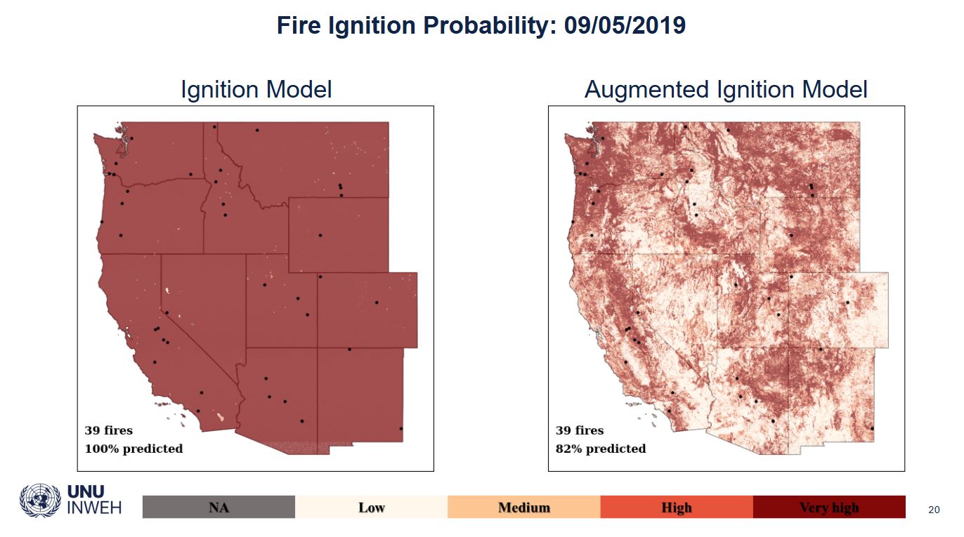
Map comparing the previous model with Sadegh’s predictive AI model. (Credit: Mojtaba Sadegh)
The other thing AI does well is applying what data we do have to other situations. If we train a model well, we can use the observed data that we have collected and apply that to study other locations for which we have not collected data. For example, we only have so many fires that we can observe soil burn severity for. But when we have observed several of them, they provide enough information to constrain an AI model that we can apply anywhere in the west. That generalizability is something that has been missing in many traditional statistical models.
Obviously there’s a ton of work that goes into getting the model to a place where you can act on its results, but once you do, these tools can help identify what we call sensitive areas that might be vulnerable to WUI fires or whatever metric you’re interested in. We have been working with fire managers to improve their efficiency and effectiveness so that our results can be used for saving lives, saving money, saving property, and improving human lives.
What are the challenges in using AI?
A lot of my work is larger scale — say, continental to global — and at that scale, because we have satellites and other means of observation, we have a lot more data. But at the smaller scales we’re now trying to work at, we have a larger issue with data shortages. If you’re interested in a pixel that was sagebrush but has recently changed into cheatgrass, there is a lot of uncertainty in that data.
That’s why I’m so glad that the HDRFS project is working to bridge that gap. Our two approaches are complementary, so we can do a lot of good work together.
 Acknowledgement: This material is based upon work supported by the National Science Foundation under Grant No. OIA- 2148788.